La Selva Sloths | Retrieving the GPS Collars
Back in June 2023, we ventured into the lush rainforest of La Selva Biological Station and Reserve to fit GPS collars on three sloths there: George, Misty, and Selvina. Until now, we have fitted VHF collars on sloths living in urban areas for The Urban Sloth Project (USP). However, to understand how urbanization and habitat disturbance affect them, we need to compare this data with that of sloths living in healthy habitats, such as old-growth primary forests.

The GPS collars we currently use have a great feature: we can download the data they collect wirelessly from them. We only need to use a special antenna called the PinPoint Commander and stand within the signal’s radius. So, at the end of August 2023, we went back there to download the first batch of data.

The collars are also equipped with an automatic Drop-Off system. This is crucial as it eliminates the need to recapture the sloth to remove the collar; instead, we retrieve the collar from the ground once the Drop-Off mechanism is activated. The Drop-Off opens the collar automatically after six months, so January 2024 was marked on our calendar as the time for a new trip to La Selva.
A setback in September
But first, let’s go back to September 2023, when La Selva staff contacted us to report finding one of the collars on the ground, although the Drop-Off had not been activated. This was due to a malfunction where the bolt securing the collar failed, inadvertently allowing Misty, the sloth, to remove it. We opted to retrieve and keep her collar at our headquarters after downloading its data.

So, before our January trip to La Selva, we verified that Misty’s collar’s Drop-Off had indeed been successfully triggered, suggesting that the Drop-Off mechanisms on the other two collars, belonging to George and Selvina, should have also been activated.
Day 1: A Plan from 8 to 10
Upon our arrival at La Selva in the evening, we immediately developed a plan to recover the collars. The necessity for a plan stemmed from the unique operational characteristics of these GPS collars compared to the standard VHF collars we use in the South Caribbean.
The GPS collars function according to pre-set schedules we establish, which dictate the intervals for GPS location tracking, data download windows, and beacon signal activation, which allow us to find it. Such scheduling allows us to manage the collar’s battery life efficiently, as it cannot operate continuously around the clock.

So back then, in June, we decided to activate the beacon signal between 8 AM and 10 AM only, thinking it would be sufficient for our purposes. This is a great approach since it conserves battery while ensuring data collection, but the challenge is the limited window to track the collar—only two hours daily.
If we fail to locate it within this timeframe, our only way to retrieve it would be a visual search—a near-impossible task given the small size of the collar and the dense rainforest terrain. Without the precise location provided by the beacon signal, finding the collar by sight alone is like searching for a needle in a haystack.

Day 2: Unexpectations
We arrived at the first location right before 8 AM, waiting for Selvina’s collar signal to start. The signal was strong, and we had a clear direction on where to go. We also checked George’s signal, which was weaker. So, we prioritized following the weaker signal first.
George’s signal led us close to the tree where he had initially been captured in June. Navigating around fallen trees, the signal eventually became stronger. A challenge emerged when we realized the signal was coming from high up in a tree, not from the ground as expected. The collar, despite the Drop Off being activated, was likely still lodged in the tree.
We spent the entire day searching, and despite our efforts, the collar was nowhere to be found. During dinner, we decided to start the next day with a search for Selvina’s collar, hopeful for better success.

Day 3: Success!
The next day, we resumed our search at 8 AM and quickly located Selvina’s collar within just 20 minutes. We found it on the ground, missing its antenna, but with the data logger still attached and the Drop-Off mechanism successfully activated.
With still 1 hour and 40 minutes left, we hurried to George’s location, approximately 300 meters (about 984 feet) from where we found Selvina’s collar. We continued to receive the signal from the same tree. After some time, José spotted the white part of the data logger attached to the collar, about 8 meters (approximately 26 feet) up, lodged in a branch.

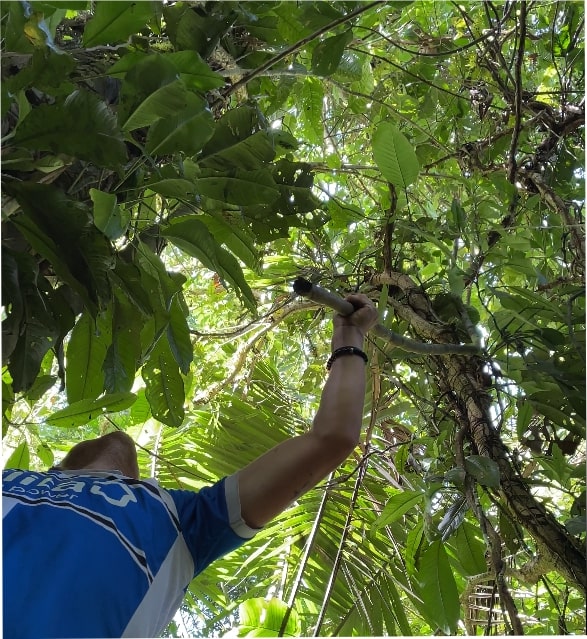
Jack, our volunteer, climbed the adjacent tree as high as possible and used a long bamboo stick we found nearby to dislodge the collar. After a 10-minute struggle, Jack freed the collar from the branch, and caught it mid-air! We were overjoyed by this success, having achieved the objectives of our trip!

The data travels across the ocean
After our successful recovery mission, we took a well-deserved lunch break before returning to Puerto Viejo. The following day, we took on the task of downloading all the data from the GPS collars and the data loggers. The crucial information was then prepared for transfer to Amelia Symeou, our data scientist working from Swansea University in the UK.
Given the design of these collars, their lifecycle concludes with the activation of the Drop-Off mechanism. The collars are sealed devices and they cannot be recharged. The only reusable part is the Data Logger, which can be erased and recharged after downloading the data on a computer.

The raw data from the GPS collars, once downloaded, includes information on temperature, altitude, latitude, and longitude. This data complements the information collected by the Data Loggers, which capture millions of different data points. Processing this substantial amount of data requires specialized computers and analysis skills.
Looking ahead, our next venture into La Selva will focus on conducting Home Range Surveys. These surveys will utilize the GPS data collected by the collars to analyze and understand the movement patterns and territorial range of the sloths.
-José Pablo Guzmán García
The Urban Sloth Project Lead Researcher


